Transit of Venus 2012 - Weather Prospects by Jay Anderson
After an 8-year hiatus, Mother Nature seems set on making amends for the geographical limitations of 2004 transit of Venus by giving those who missed out the first time a chance to redress their loss in June 2012. Just in time too, as the next transit, in 2117, will surely come after every spectator of the coming event has passed on. With only one chance for success, weather will be a critical player in the spectacle. Fortunately, transits are not eclipses, and the 6 hours and 40 minutes of solar-crossing time will give an opportunity to exploit an opening in the clouds or to move to a new location. Alternatively, spectators (is there such a thing as a transit-chaser?) can travel to a meteorologically more promising area ahead of time.
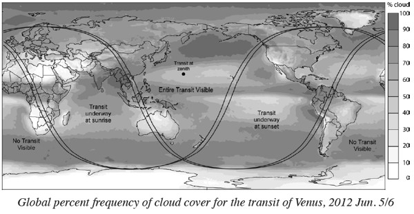
Lest she seem too generous, Nature has limited the zone in which the whole of the eclipse is visible to the central and western Pacific, to countries along the western edge of the ocean, and to the northern latitudes of the world (see p. 145). For most of Canada and the whole of the United States, the Sun will set while the transit is in progress. For Europe, northeast Africa, and India, the transit will be in progress when the Sun climbs above the horizon. The rest of the globe—western Europe, western Africa, and most of South America—had their chance in 2004.
For the serious transitophile, only the entire spectacle will suffice, especially as the most interesting moments of a Venus crossing are at the start and end of the process, when the backlit planet shines as a tiny ring on the limb of the Sun. Within that zone of transit “totality,” one country stands out above all others for its good weather during the event: Australia (“Oz” to the locals), and only eastern and central Australia at that, as the transit starts just before sunrise in the west. Sydney is fine, but observers in Perth will miss the entry of the planet onto the solar disk. The satellite-based cloud-cover map (see below) shows that the average cloud cover is lowest in the Outback in the Northern Territories.
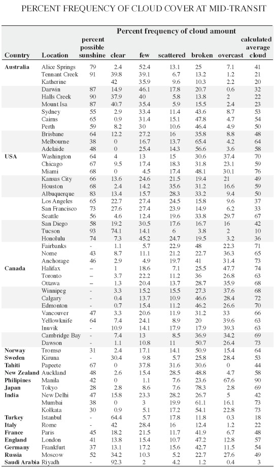
The climate statistics in the Table (overleaf) emphasize the patterns revealed in the satellite data. The heart of Australia’s sunshine climatology lies between Tennant Creek and Katherine, along the Stuart Highway. Nearly cloud-free skies in June bathe that part of the Northern Territories with over 90% of the maximum possible amount of sunshine. The rest of the Outback is similarly endowed by favourable weather, particularly toward Mount Isa in Queensland. Cloudiness increases toward the south and east, where an ocean-fed atmosphere encounters the mountains along the coast.
After Australia, the Hawaiian Islands offer the most promising transit venue, though the Big Island just qualifies as a site to watch both ingress and egress. Sunshine statistics improve toward the northwest along the Hawaiian chain, but there is also considerable variability in cloud amounts on individual islands. In general, but not infallibly, the windward (eastern) sides of the islands are cloudier than the leeward, as the trade winds tend to create cloud on the side where they first encounter land. On the Big Island, windward Hilo has an average cloud amount of 66% versus 49% at leeward Kona. The comparable statistics for the island of Hawaii show 53% average cloudiness at Kaneohe Bay compared to 39% at Honolulu. The best statistics however are not in Hawaii, but instead belong to Midway Island, with an average cloudiness of 20%, comparable to the best in Australia. No sunshine statistics are available for Midway.


On the North American continent, excellent transit-viewing sites can be found along the Pacific coast and over the southwest deserts, though the egress will take place after the Sun has set. Coastal California statistics show that sunshine averages 60 to 65% of the maximum possible, but this is overshadowed by the climatology of Arizona; Tucson and surroundings accumulate 93% of the maximum sunshine for June, a value slightly higher than the best of Oz. To see the entire transit, travel to Canada’s northern regions is required. Yellowknife offers the most promising cloud and sunshine statistics of any northern site, Europe or North America, with sunshine hours averaging 64% of the maximum—and you can drive there.
Elsewhere in the U.S. and Canada, cloud prospects cannot match those of the southwest. June is prime thunderstorm season, and cloudiness increases steadily from west to east, reaching a maximum over the Appalachians and along the Atlantic seaboard. Nevertheless, a little mobility will probably permit any determined Venus-watcher to get a view of the transit, as weather forecasting is certainly capable of giving a three- or five-day heads up for the transit—lots of time to drive to a more promising location.
Point Venus in Tahiti has a historical cachet, being the site at which Cook observed the transit in June 1769. The transit in 2012 is just short of being visible in its entirety from Point Venus or other venues in Tahiti, but French Polynesia is in its dry season in June and the weather is cooperative. Sunshine averages 67% of the maximum at Papeete, among the better spots in the south Pacific.
Through Southeast Asia and China, the monsoon season is in its early stages, and cloudiness is endemic. Of all of the sites along the shores of the eastern Pacific, the Northern Philippines and Taiwan straddle the low-cloud regime created by the permanent high-pressure cells that inhabit that latitude. Over Africa, the Middle East, and India, good weather prospects stretch from the Sahara across Egypt and Turkey into Iraq and Afghanistan. For an absolute sure-fire guarantee of a view of at least a part of the transit, it’s hard to beat the statistics for Riyadh in Saudi Arabia: an average cloud amount of 3%.
This article first appeard in the Observer's Handbook 2012, 153-155. We thank Jay Anderson and David M.F. Chapman for permission to reproduce it here.
| Attachment | Size |
|---|---|
| 1.82 MB |
- Log in to post comments
